Two waves of potential severe weather tonight through early Friday
By Jim Stefkovich, Meteorologist, Alabama Emergency Management Agency
A few thunderstorms will develop along a frontal boundary this afternoon through tonight north of I-20. A few storms in northwest AL could produce damaging wind gusts near 60 mph and quarter size hail from 10 pm tonight through 5 am Thursday. Although the tornado threat is very low, 1-2 could develop.

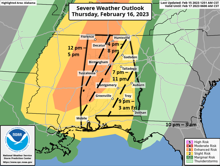
Then, a line of thunderstorms ahead of a strong cold front that will move from west to east across the state Thursday afternoon through early Friday morning. In addition, a few supercell thunderstorms are possible both within and ahead of the line. All modes of severe weather could occur and all watches will be Tornado Watches.
Unfortunately, the atmospheric parameters are such that strong, long-tracked tornadoes are possible within the Enhanced Risk area (orange shaded in graphic at top of page), as well as straight-line wind gusts to 70 mph and large hail. Also, non-thunderstorm winds ahead of the line of storms will be on the increase statewide during the day on Thursday with gusts from 25-35 mph.
Much colder air will filter into most of Alabama on Friday. Low temperatures early Friday morning will range from the middle 30s north to middle 50s south with high temperatures from the middle 40s north to upper 50s south. Gusty northwest winds from 20-25 mph will also occur. Low temperatures Saturday morning will range from the middle 20s north to middle 30s near the coast.
It is VERY IMPORTANT you have at least two methods to receive severe weather warnings, one of which does NOT include an outdoor warning siren.
NOAA Weather Radio, making sure Wireless Emergency Alert (WEA) for your cell phone is turned “on”, and other Apps from a trusted source are all options. Why two methods? First, outdoor warning sirens are meant for people outdoors, and they can fail. Second, any other source can fail at times for a variety of reasons. Don’t let a single point of failure make you miss a life-saving warning!
If you have never developed a severe weather plan or haven’t reviewed your current one in some time, go to Severe Weather | Ready.gov . Do it today and be prepared before severe weather strikes. Trying to figure out what to do in a middle of a warning is a recipe for disaster.