
Be prepared for severe weather this afternoon
Madison, Madison County Record, News, RSS Twitter, Z - News Main
 By  John Few Published 
8:15 am Sunday, April 12, 2020

Be prepared for severe weather this afternoon

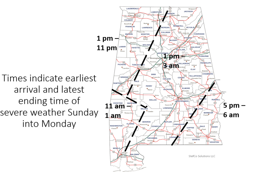
A severe weather outbreak is expected across the Tennessee Valley region this afternoon and evening. All modes of severe weather will be possible, including tornadoes, damaging winds and large hail. The greatest risk of severe weather will be from 3 pm through Midnight.
Click here for a list of official tornado shelters in Madison County.

By Jim Stefkovich, Meteorologist, Alabama Emergency Management Agency

By this afternoon, southerly winds will increase outside of thunderstorm activity with gusts of 35-45 mph statewide. This could down small or weakened trees. In addition, through early Monday morning, widespread 2-4 inches of rain will occur with some locations receiving 5+ inches in stronger storms.

Nothing has changed concerning severe weather as the entire state is under a Moderate or Enhanced Risk from the Storm Prediction Center. Don’t focus on the color as long-track EF2+ tornadoes are possible statewide as well as significant straight-line wind damage and hail to the size of tennis balls.

As with all of these type events, will every county actually have severe weather today or tonight? Probably not. But, is there a significant threat and potential for severe weather in every county? Absolutely! That’s why every person in the state should already have their safe location identified, can receive watches and warnings by at least two methods (outdoor sirens are NOT a reliable method!), and know what to immediately do when a warning is issued.

You can find out more information by going to https://www.ready.gov/severe-weather

Don’t be scared, be prepared!

If there is any good news, it’s that the weather from Monday – Friday is forecast to be mainly rain-free with no additional severe weather.

Also on The Madison Record
Long-sought aquatic center to be built in Dublin Park
Madison County Record, News, Schools, ...
By STAFF REPORTS 
September 9, 2026
MADISON - Madison City Schools and the City of Madison are teaming up on plans to build an Aquatic Center in Dublin Park. Mayor Ranae Bartlett and MCS...
Rocket City Classic to host two games in 2026
Madison County Record, News, Sports, ...
By BOB LABBE 
September 9, 2026
HUNTSVILLE- The 2026 Rocket City Classic has expanded to two games. The latest announcement from the Huntsville Sports Commission and the Von Bran Cen...
U.S. Open semi-finalist Ben Shelton’s local connection
Events, Madison County Record, News, ...
By BOB LABBE 
September 9, 2026
HUNTSVILLE- The tennis action will be fast and furious this weekend at the Athletic Club Alabama, located on Leeman Ferry Road in Huntsville, as the m...
9/11 Memorial Stair Climb at Toyota Field to remember first responders in World Trade Center
A: Main, Events, Madison County Record, ...
Gregg Parker 
September 9, 2026
MADISON – At 8:46 a.m. on Sept. 11, 2001, five hijackers diverted American Airlines Flight 11 to downtown New York City and crashed into the northern ...
Battle of the Bands to be held at Home Place Park this Saturday
A: Main, Events, Madison County Record, ...
Gregg Parker 
September 9, 2026
MADISON – “Battle of the Bands” is returning this Saturday to decide who will rule the stage at Home Place Park, 100 Shorter Street. Madison Arts Alli...
Neighborhoods, businesses earn beautification awards with pleasing landscaping
Lifestyles, Madison County Record, News, ...
Gregg Parker 
September 9, 2026
MADISON – Bright crimson blooms on petunias. Subtle hues of begonias. Snow-white blossoms of geraniums. Arrange these flowers amongst manicured shrubs...
Watercolor, romance and pumpkins ready at Blue Apple Books in September
Business, Events, Lifestyles, ...
Gregg Parker 
September 9, 2026
MADISON – Visual art, affectionate feelings, a celebration and pumpkins . . . yes, pumpkins are early harbingers of approaching autumn at Blue Apple B...

Leave a Reply

Your email address will not be published. Required fields are marked *